Picture this: you're on a remote trail in the Greek mountains or drifting in the middle of the Aegean, hours from the nearest harbor. Something goes wrong — a broken ankle, an engine failure, a sudden medical emergency. You reach for your phone: zero bars. No network. No signal whatsoever. Until recently, this meant total isolation. Today, thanks to satellite SOS technology, your smartphone can become your lifeline — even without any cellular towers or WiFi in range.
📖 Read more: Satellite Internet for Greek Islands: Complete Guide 2026
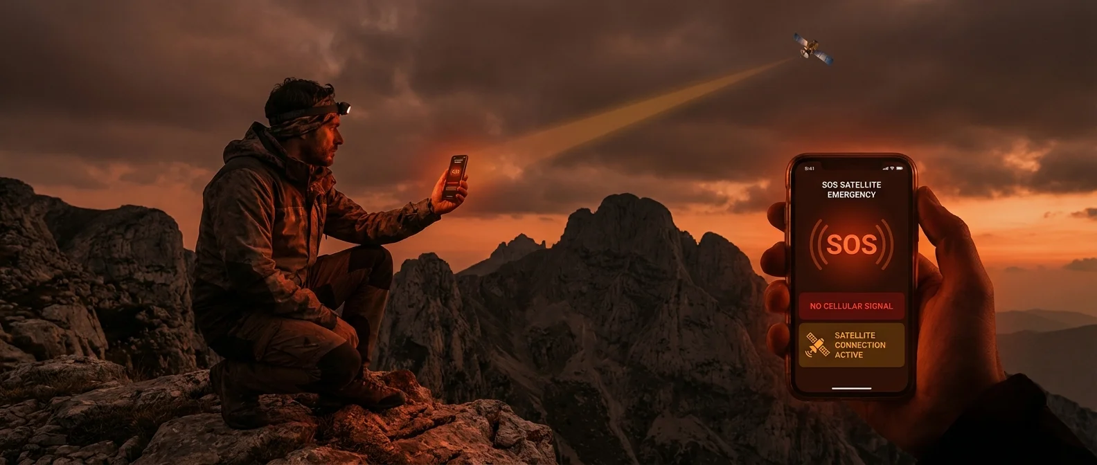
🆘 What Is Satellite SOS?
Satellite SOS is a technology that allows a smartphone or dedicated device to communicate directly with orbiting satellites, completely bypassing terrestrial cellular networks. This means that even in locations with zero coverage — mountains, open ocean, remote islands, dense forests — a user can send an emergency distress message, transmit their GPS coordinates, and call for help.
Here's how it works: the phone detects a low Earth orbit (LEO) satellite passing overhead and guides the user — through on-screen instructions — to point the device toward the right spot in the sky. Once a connection is established, a compressed SOS message is transmitted along with precise location coordinates. The message reaches a relay center, which then dispatches the appropriate emergency services — coast guard, fire department, ambulance, or mountain rescue, depending on the situation.
Unlike traditional satellite phones that cost thousands of euros, modern technology embeds this capability into everyday smartphones you already carry in your pocket. Let's look at the numbers:
This technology has already saved lives. Since its launch in September 2022, dozens of documented cases worldwide include hikers lost in mountains, stranded sailors in open water, and accident victims in remote areas — situations where, without satellite SOS, help would never have arrived in time. This isn't a gimmick — it's a genuine rescue mechanism.
📱 Apple Emergency SOS via Satellite
Apple was the first company to bring satellite SOS to a mainstream smartphone. The Emergency SOS via Satellite service launched in September 2022 alongside the iPhone 14, leveraging the Globalstar satellite constellation — a network of 25 second-generation satellites in low Earth orbit (LEO).
Globalstar was founded in 1991 as a Loral/Qualcomm joint venture and evolved into a key telecommunications provider. In October 2024, Apple acquired a 20% stake in Globalstar, securing 85% of the network's capacity exclusively for its SOS service. Simultaneously, 10 new ground station gateways were built worldwide for faster signal processing.
The service is available on all iPhone 14, 15, and 16 models. It's free for the first 2 years from each device's activation — after which a paid subscription is expected, though pricing hasn't been announced yet. It works without any cellular or WiFi coverage — all you need is a clear view of the sky toward the satellite.
In practice, when you dial your local emergency number (112 in Europe, 911 in the US) with no signal, the iPhone automatically presents the "Emergency SOS via Satellite" option. You follow the on-screen prompts, pointing your phone where the directional indicator shows, and within 15-30 seconds you're connected. A short, structured message is sent — Apple uses a multiple-choice questionnaire for a brief but accurate description — along with your exact GPS coordinates.
📋 Apple Emergency SOS — Key Features
- Devices: iPhone 14, 15, 16 (all models)
- Network: Globalstar — 25 LEO satellites
- Cost: Free for the first 2 years, then subscription
- Connection time: 15-30 seconds (clear sky)
- Type: One-way SOS transmission + GPS location
- Limitations: No voice calls or data — structured messages only
- Requirements: Clear sky view, updated iOS, active Apple ID
- Bonus: Find My via Satellite — share your location with friends/family even without signal
A notable bonus is Find My via Satellite: even if you don't trigger an SOS, you can share your location with family or friends through the Find My network using the same satellite link. This is perfect for hikers or travelers in remote areas who simply want loved ones to know they're safe.
🤖 Android & Other Satellite SOS Solutions
Apple may have led the way, but the competition is catching up fast. Google added satellite SOS to Pixel phones in 2024, while Samsung is integrating similar functionality into its latest Galaxy models. Huawei, starting with the Mate 50 series (2022), offers satellite messaging via China's BeiDou navigation system — primarily for the Chinese market, but it signals a broader industry trend.
📖 Read more: Direct-to-Cell: Satellite Internet on Your Regular Phone
Beyond smartphones, there's a well-established ecosystem of dedicated satellite communication devices that have been used for years by hikers, mountaineers, sailors, and professionals in remote locations. Here's how the options compare:
📊 Satellite SOS Solutions Compared (Feb. 2026)
| Device | Network | Type | Device Cost | Monthly Fee | SOS | Two-Way Messaging |
|---|---|---|---|---|---|---|
| iPhone 14/15/16 | Globalstar | Smartphone | ~€850-1,400 | Free (2 years) | ✓ | ✕ (SOS only) |
| Pixel (2024+) | Varies | Smartphone | ~€500-1,000 | Free | ✓ | ✕ |
| Garmin inReach | Iridium | Standalone | ~€350-450 | €15-50 | ✓ | ✓ |
| SPOT Messenger | Globalstar | Standalone | ~€150-200 | €12-20 | ✓ | ✕ (one-way) |
| Satellite Phone | Iridium/Thuraya | Dedicated device | ~€800-2,000 | €30-150+ | ✓ | ✓ (+ voice) |
The Garmin inReach deserves special attention. It uses the Iridium constellation — 66 satellites in near-polar LEO orbits with inter-satellite links, providing true global coverage including the poles. It offers two-way messaging (you can receive replies on the mountain), emergency SOS, and real-time GPS tracking. It's the go-to device for serious hikers, skiers, and mountaineers worldwide, costing ~€350-450 for the unit plus ~€15-50/month for the subscription.
The SPOT Satellite Messenger uses the Globalstar network and represents the most budget-friendly option: ~€150-200 for the device, ~€12-20/month. However, it only provides one-way SOS and tracking — you can't receive messages back. Suitable for basic safety on treks or trips where you just need someone to know where you are.
Satellite phones (Iridium, Thuraya, Inmarsat) remain the most complete solution — voice calls, SMS, data — but at a steep price: €800-2,000 for the handset, roughly €1-2 per minute for calls, and bulky hardware. Typically used by war correspondents, polar explorers, and maritime companies — not your average outdoor enthusiast.
🛰️ Starlink Direct-to-Cell: The Next Generation
While satellite SOS saves lives in emergency scenarios, the real revolution lies in bringing everyday satellite connectivity to ordinary phones. SpaceX is making this a reality through Starlink Direct-to-Cell.
Since July 2025, satellite-based SMS service has been operational in the US and New Zealand through partnerships with T-Mobile, AT&T, and Verizon. It uses second-generation Starlink satellites equipped with LTE antennas that beam signals directly to regular smartphones with zero modifications required. No special app, no extra hardware — it simply works on your existing phone.
The SMS phase is just the beginning. SpaceX plans to gradually add voice calls and eventually mobile data via satellite. Imagine: no dead zones anywhere on Earth — even in the middle of the Atlantic, on a Greek mountain peak, or on a tiny island with no cell tower, your phone will have coverage.
Meanwhile, AST SpaceMobile is developing a satellite network fully compliant with the 3GPP standard and has already achieved the first-ever 5G connection via satellite directly to an unmodified phone. And Iridium announced "Project Stardust" in January 2024 — a 5G IoT and direct-to-device program aiming to connect billions of IoT devices in remote locations.
"We are living through the last days of dead zones. Within 3-5 years, the phrase 'no signal' will be a thing of the past everywhere on the planet — thanks to low Earth orbit satellites. This doesn't just change telecommunications; it changes the rescue of human lives in emergency situations."
Expansion to European countries, including Greece, is expected within 1-2 years, pending regulatory spectrum approvals. European carriers are already in discussions with SpaceX about delivering Direct-to-Cell services to their subscribers.
🇬🇷 The Greek Reality: When You'll Need It
Greece, with its mountainous terrain (80% of the land is hilly or mountainous), thousands of islands, and vast maritime borders, creates countless scenarios where satellite communication can mean the difference between life and death. This isn't hyperbole — every year dozens of hikers, swimmers, sailors, and travelers find themselves in danger at spots with zero cellular coverage.
📖 Read more: Non-Terrestrial Networks: Connectivity Beyond Earth
Mountain Hiking
The European E4 trail crosses Mount Olympus, Psiloritis in Crete, and the White Mountains (Samaria Gorge). Dozens of kilometers with no cell signal. A twisted ankle or sudden weather change can turn dangerous fast without any way to call for help.
Sailing & Boating
Sailing the Aegean — especially between the Cyclades and Dodecanese — means crossing vast stretches of open sea with no coverage. An engine failure, medical issue, or sudden meltemi wind can be fatal without the ability to make a call.
Remote Islands
Small Aegean islands with minimal coverage — or even larger ones, at points far from villages. Hiking on Ikaria, Amorgos, or Anafi means hours on trails with no signal — an ideal scenario for satellite SOS.
Mountain Driving
Roads in Epirus, the Mani Peninsula, highland Arcadia, and Evrytania pass through many dead zones. A breakdown or accident on an isolated road at night demands a way to call for help.
According to data from the Hellenic Coast Guard and Fire Service, hundreds of rescue operations take place in Greece every summer. A significant percentage are delayed due to the inability to communicate. Satellite SOS technology can dramatically reduce response times — from hours to minutes.
💡 Practical Tips: Get the Most Out of It
The technology exists — but without proper preparation, it won't help you when you need it most. Here are practical tips to ensure you're always ready:
1. Set it up before you need it. If you own an iPhone 14 or newer, go to Settings → Emergency SOS and complete the setup. Fill in your Medical ID (allergies, medications, emergency contacts). Try the demo mode — Apple provides a test satellite connection without triggering an actual SOS call.
2. Keep your phone charged. Connecting to a satellite draws significant power. On any hike or marine excursion, always carry a power bank. Ideally, maintain at least 30% battery reserve.
3. Know the limitations. Satellite SOS does not replace a regular call to 112 (or 911). It only works with clear sky — indoor spaces, dense forests, and deep ravines may block the connection. Messages are short and structured — you can't have a free-form conversation.
4. Consider Garmin inReach for serious outdoor activities. If you regularly hike mountain trails, do long-distance sailing, or spend time in remote locations, the Garmin inReach offers two-way communication via Iridium — meaning you can receive replies on the mountain. The ~€400 investment plus €15-50/month subscription can literally save your life.
5. Tell someone your plans. Make sure someone knows your route and expected return time. Even with satellite SOS, the most important safety measure remains prevention and proper planning.
6. Keep your software updated. Apple and Google continuously improve their satellite connection algorithms. Keep your iOS or Android on the latest version for optimal performance and new features. Don't skip updates — they may include critical improvements to satellite connectivity.
⚠️ Important Reminders
- Satellite SOS does not work indoors — you need open sky
- Connection time may increase in bad weather or dense vegetation
- Always keep your iOS/Android updated for the latest satellite improvements
- Store offline maps on your phone for navigation without network
- At sea, always carry a VHF radio on your boat — it remains the most reliable form of maritime communication
Satellite SOS technology is transforming our smartphones into rescue tools. From Apple's free Emergency SOS via Satellite to the Garmin inReach and the coming Starlink Direct-to-Cell infrastructure, each generation of technology brings us closer to a world without dead zones. For Greece — with its mountains, islands, and vast seas — this isn't a luxury. It's a necessity. Set up your device today, hoping you'll never need it — but knowing that if you do, it'll work.