📖 Read more: No-Fly Zones in Greece: Where Drone Flight Is Prohibited
⚖️ What the Law Says
Under EASA Regulations (EU) 2019/947 and 2019/945 — in effect across Greece since January 1, 2021 — every drone flight is subject to specific rules. The HCAA is the national aviation authority and requires a flight application for each individual flight via email at uas@hcaa.gov.gr. Applications must be submitted at least 3 business days in advance (5 business days if the area falls within a military zone).
Core rules include: maximum flight altitude of 120 meters (393 feet), mandatory visual line of sight (VLOS) at all times, no night flights, and a maximum flight area of 1,000×1,000 meters to ensure VLOS compliance. If your intended area is larger, you must split it into smaller segments (Area #1, #2, etc.).
Since January 2024, all drones operating in the Open Category must carry a class identification label (C0 through C4) — unless purchased before December 31, 2023 or privately built. Operator registration with the HCAA is mandatory for drones over 250g or equipped with a camera, and obtaining an A1/A3 certificate (free online exam) is the minimum requirement.
🟢 Green Zones: Where You Can Fly
Greece offers vast expanses where drone flight is feasible — provided your application through DAGR has been approved. Areas that typically receive easy approval include:
Rural & Sparsely Populated Areas
The Greek countryside is the freest space for drone flying. Farmland, olive groves, hills, and open plains — as long as they're not near an airport, military installation, or archaeological site — make ideal locations. Subcategory A3 (fly far from people) is most suitable here, allowing drones of all classes (C2, C3, C4) provided you maintain at least 150 meters from residential areas.
Remote Beaches & Coastlines
Uninhabited beaches and rocky coastlines deliver stunning footage. Spots like secluded bays in Milos, Lefkada, or southern Crete offer turquoise waters and dramatic cliffs with minimal human presence. The key condition is that no airport is nearby (always verify on DAGR) and that you maintain distance from swimmers.
Mountain Landscapes & Gorges
Mountain peaks, highland villages, and gorges provide spectacular backdrops. Areas like Tymfi in Zagori, Taygetus in the Mani, or the mountains of Evia are typically approved as long as they don't fall within a Natura 2000 zone or military area. Note: in gorges, VLOS can be lost easily, so keep your drone close.
Islands: A Drone Pilot's Paradise
Greek islands offer unique aerial photography opportunities. However, each island has its own quirks. Islands without airports (e.g., Milos, Folegandros, Sifnos, Hydra) offer greater freedom. Islands with airports (Santorini, Mykonos, Rhodes, Corfu, Kos) have restricted CTR zones around the airfield — on small islands, this can cover a significant portion of the land. Santorini, for instance, due to its small size and central airport location, has restrictions across much of the island.
Urban Areas: Proceed With Extreme Caution
Flying in urban environments isn't completely banned but comes with strict limitations. In subcategory A1, you can fly over people (not assemblies) only with a C0 (<250g) or C1 (<900g) drone. In subcategory A2, with a C2 drone (<4kg), you must maintain at least 30 meters (or 5 meters in low-speed mode) from people. Regardless, your DAGR application must be approved first.
🔴 Red Zones: Where Flying Is Prohibited
Certain areas in Greece are strictly off-limits for drones — regardless of size or purpose. Violations can result in fines ranging from €1,000 to €50,000 (~$1,090–$54,500) and criminal prosecution.
Airport Control Zones (CTR)
Every airport in Greece has a Control Zone (CTR) with a typical radius of 8 kilometers. Within this zone, drone flights are strictly prohibited without special authorization from air traffic control. Greece has 39 airports — the most significant CTRs affecting tourist drone pilots:
- Athens (LGAV): The largest CTR — covers Markopoulo, Rafina, Spata, Koropi, and parts of Eastern Attica
- Thessaloniki (LGTS): Covers Thermaikos Gulf, Kalamaria, Peraia, Michaniona
- Heraklion (LGIR): Central Crete — includes parts of the Ammoudara-Kokkini Hani coastline
- Rhodes (LGRP): Northern section — covers Rhodes town and northern beach
- Santorini (LGSR): Much of the island due to its small size
- Corfu (LGKR): The CTR extends over Kanoni, Pontikonisi, and the central town
- Mykonos (LGMK): SE section — affects the area near the town center
- Chania (LGSA): Military + civilian — extended zones around Akrotiri
For each airport, the exact CTR shape is visible on DAGR. Don't rely on distance alone — some CTRs have irregular shapes that may extend further in certain directions.
Military Installations
Greece, due to its geopolitical position, has numerous military bases and installations across the country. In the DAGR system, these appear as “MIL” (Military) zones. Flying in these areas is strictly prohibited, and even if your neighboring area application is approved, the flight zone must not overlap with a MIL zone. If your intended flight is near a military airfield (e.g., Souda, Elefsina, Andravida, Larissa, Tanagra, Araxos), the application requires coordination with military authorities — hence the 5-business-day deadline.
Archaeological Sites & Monuments
Greece is home to 18 UNESCO World Heritage sites and hundreds of archaeological sites. Flying a drone over these requires written consent from the site manager — namely the Ministry of Culture or the relevant Ephorate of Antiquities. In practice, this means that without special permission, you cannot fly over:
- The Acropolis, Parthenon, and Ancient Agora of Athens
- Delphi, Temple of Apollo
- Olympia, ancient stadium
- Knossos, Minoan Palace
- Meteora monasteries
- Mycenae, Epidaurus, Delos
- Medieval City of Rhodes
- Old Town of Corfu
The permit process through the Ministry of Culture depends on the purpose (amateur, documentary, commercial) and can take weeks — in some cases, it's denied outright. For the average drone pilot, archaeological sites are essentially a no-go.
Sensitive Government Facilities
The law explicitly prohibits flights over prisons, hospitals, government buildings, critical infrastructure (power stations, refineries, dams), nuclear facilities, and defense installation security perimeters. Violating these restrictions is considered a serious criminal offense.
🟡 Gray Zones: Where Special Permission Is Required
Beyond the clearly green or red zones, there are areas where flying is possible but only with special authorization. These represent the most ambiguous cases.
Natura 2000 Areas & National Parks
Greece has 446 Natura 2000 sites covering approximately 28% of its land area. In many of these, drone flights may be restricted due to wildlife protection — especially during bird breeding seasons. National parks such as Olympus National Park, Lake Kerkini, Amvrakikos Gulf, and Ainos National Park (Kefalonia) may have additional restrictions. Always check DAGR and contact the management authority.
Ports & Coast Guard
Major ports (Piraeus, Thessaloniki, Patras, Heraklion) may have restrictions due to maritime safety. At ports with military use or coast guard facilities, flying may require additional authorization.
Events & Gatherings
Flights over assemblies of people (concerts, sports events, protests, festivals) are strictly prohibited under EASA regulations. Even in areas that are normally “green,” the temporary presence of an event automatically turns them into a no-fly zone.
✅ Fly Freely (with DAGR application)
- Rural areas & plains
- Remote beaches & bays
- Mountain landscapes & hills
- Islands without airports
- Countryside & olive groves
- Open sea (near coastline)
⛔ Prohibited / Special Permit Required
- Airport CTR zones (8km radius)
- Military bases (MIL zones)
- UNESCO archaeological sites
- Prisons, hospitals, government buildings
- Assemblies of people
- Natura 2000 (in certain seasons)
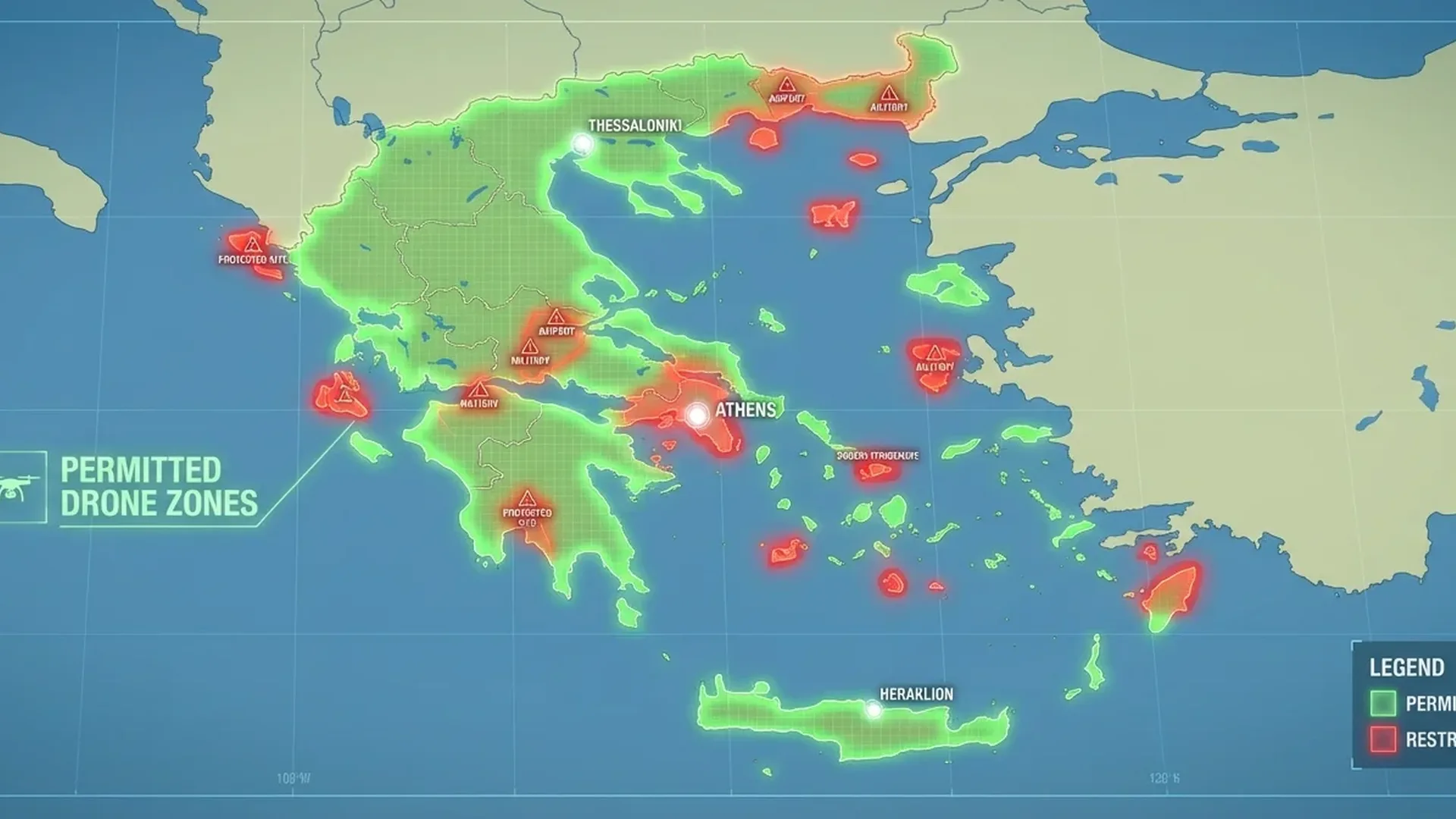
🗺️ DAGR: The Digital Flight Map
Drone Aware GR (DAGR), available at dagr.hasp.gov.gr, is every drone pilot's essential tool in Greece. Developed by the Hellenic Aviation Service Provider (HASP), it delivers real-time information about flight zones.
The DAGR map displays color-coded zones: red for prohibited areas, orange for restricted zones, and green for open areas. Each zone carries labels (e.g., “MIL” for military, “CTR” for airports), and clicking on them reveals detailed information.
DAGR serves not only as an information resource but also as a flight application tool. You can draw your intended flight area directly on the map (circle or polygon), copy the coordinates, and include them in your application. To activate the drawing tool, select the pencil icon in the lower left — the “AREA DRAWING MODE” indicator will appear.
💡 Pro Tip: Before any trip, open DAGR and check your destination area. Even if a location “looks safe,” it might fall within an invisible military or aviation zone. Save yourself time and fines — always check first.
📝 Flight Application Process Step-by-Step
Flight applications to the HCAA are submitted exclusively via email at uas@hcaa.gov.gr. The application must remain in editable form and include the following:
- Brief description of flight activity — what you plan to do (photography, videography, training, etc.)
- UAS operator registration number — with proof per EASA (EU) 2019/947
- Remote pilot certificate — A1/A3 and/or A2 (not required for drones under 250g)
- Completed flight table — the official form (available at ypa.gr)
- Open Category declaration — confirming all flights comply with Articles 4 and 22 of (EU) 2019/947
- Area coordinates — from DAGR (circle or polygon, max 1,000×1,000m)
- Exact date and time of flight
- Written consent (if applicable) — for overflying monuments or government structures
Applications must be submitted at least 3 business days before the planned flight. If the DAGR zone shows “MIL,” the deadline extends to 5 business days for the required military coordination. The application is forwarded by the HCAA to HASP, and you receive a response via email.
📍 Popular Locations & What Applies
Several locations in Greece are particularly popular for aerial photography. Here's what you need to know about each:
Santorini (caldera, Oia, Fira): Extremely restricted. The airport sits near the island's center, and the CTR covers a large area. Oia may fall outside the CTR, but crowded streets and tourist presence create additional limitations. Always check DAGR — and avoid peak hours.
Meteora: Archaeological/religious site. The monasteries and rock formations are under UNESCO protection. Written consent from the site management is required — nearly impossible for amateur pilots. You may be able to fly in an adjacent open area as long as you don't overfly the monuments themselves.
Navagio (Shipwreck Beach), Zakynthos: A Natura 2000 area due to the loggerhead sea turtle (caretta caretta). Additionally, access is by sea only. Flying may be prohibited during breeding season (May–October). Outside this period, check DAGR.
Balos & Elafonissi, Crete: Remote beaches but Natura 2000 areas. Off-peak and during low tourist season, flights may be approved provided there's no nearby airport (Elafonissi is well outside the Chania CTR). But always verify.
Acropolis, Athens: Absolutely prohibited. UNESCO archaeological site, densely populated zone, and additional security restrictions due to government buildings. Don't even think about it.
Vikos Gorge, Zagori: Outside military zones, the Vikos Gorge area and its stone bridges are generally drone-friendly. However, the Vikos-Aoos National Park may have restrictions — check DAGR and contact the management authority.
Sarakiniko, Milos: Excellent location with no major airport on the island (only a general aviation airfield). Milos offers significant freedom for drones — especially at deserted bays and its lunar-like landscape.
⚠️ Common Mistakes & Pitfalls
Many drone pilots fall into common traps — especially tourists unfamiliar with Greek regulations:
1. "I don't need a permit if my drone is small": Wrong. Even C0-class drones (<250g, e.g., DJI Mini 4 Pro, ~€700 / ~$759) require a flight application through DAGR. The only exemption concerns operator registration (not required for <250g without camera) — but that doesn't mean free flight without an application.
2. "I flew abroad without issues, so Greece should be the same": Each country has its own rules beyond European regulations. Greece has a particularly strict per-flight application system compared to many countries.
3. "Nobody will see me in this remote spot": Greek military radar, coast guard, and local authorities monitor the airspace. Numerous fines have been imposed on tourists in precisely “remote” locations near military installations or border areas.
4. "DJI GeoFencing doesn't flag this area, so it's fine": DJI's GeoFencing system doesn't replace DAGR. It may allow flight in an area that's actually a red zone on DAGR. Always rely on the official system.
5. Flying over private property: Greek law explicitly requires the property owner's permission for drone flights over private land. In tourist areas with villas and hotels, this is a frequent source of complaints.
💰 Fines & Consequences
Violating drone flight rules in Greece carries serious consequences. Administrative fines range from €1,000 to €50,000 (~$1,090–$54,500) depending on severity — flying in an airport CTR or military zone falls at the higher end. In cases where flight safety or national security is endangered, criminal prosecution may follow. The drone is confiscated as evidence.
For tourists, fines are imposed on the spot or via a payment order before departure. In serious cases (e.g., military zone violation in border areas), detention may occur pending a court hearing.
🛡️ 10 Practical Tips for Legal Flying
- Always check DAGR first — before you even pack your drone
- Submit your application early — 5+ days ahead, especially during tourist season
- Keep a copy of the approval on your phone
- Register with the HCAA and get the A1/A3 certificate (free)
- Insure your drone — especially for commercial flights or those over 4kg (~€60–150/year, ~$65–163)
- Fly only during daytime — night flights are prohibited in the Open Category
- Keep the drone in visual line of sight — VLOS is mandatory at all times
- Avoid crowds — even if the area is approved
- Respect privacy — don't film people without consent
- Check for local rules — some municipalities and islands may have additional restrictions
"Freedom of flight doesn't mean flying without rules. A responsible pilot knows the restrictions — and finds beauty where it's allowed."
📌 Conclusion
Greece offers exceptional opportunities for aerial drone photography — from turquoise bays and moonscape beaches to mountain landscapes and traditional settlements. However, the regulatory framework is strict and demands proper preparation: HCAA registration, pilot certification, a DAGR application, and respect for flight zones.
The DAGR system is your central ally — use the map, draw your areas, submit applications promptly. With the right preparation, you can legally enjoy Greece's most beautiful corners from above — without fines, without trouble.