Why Drones Are Changing Real Estate
The real estate market increasingly relies on visual presentation. Buyers start their search online, and properties with professional aerial photography stand out immediately. According to NAR data, 64% of realtors report adopting new technology to improve client experience, while nearly half (45%) say their clients respond “very positively” to technology use.
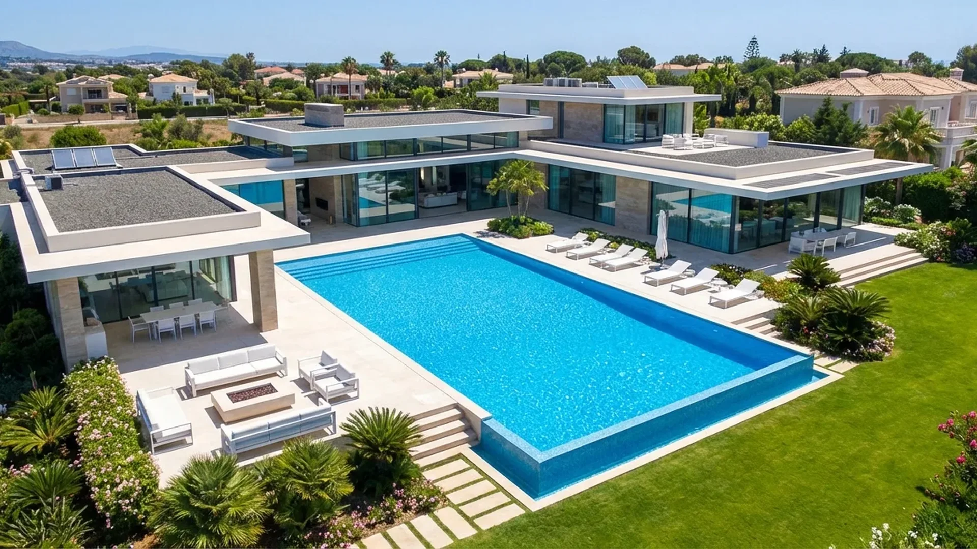
Drones offer a unique aerial perspective that ground-level photography simply cannot provide. They showcase the property's location, neighborhood, gardens, pools, parking, and nearby points of interest — elements critical for buyers who cannot physically visit the property.
Key Trend: The NAR 2025 survey showed that social media remains the top lead-generating technology (39%), followed by CRM (23%) and local MLS (17%). Drone aerial photos published on social media significantly boost listing visibility.
Drone Services in Real Estate
Drone services in real estate go far beyond basic aerial photography. According to UAVCoach data, modern drones offer a wide range of capabilities:
Aerial Photography
High-resolution aerial shots (48MP+) showcasing property location, surroundings, and nearby attractions. Ideal for homes, commercial properties, and large plots of land.
Aerial Video Tours
Cinematic 4K/5K footage presenting properties in dynamic form. Intelligent Flight Modes (e.g., orbit, waypoint) create stunning automated shots.
3D Virtual Tours
Platforms like Matterport create interactive 3D walkthroughs — “24/7 open houses” — allowing buyers to explore every room without physical presence.
Orthomaps & Floor Plans
Plot mapping, drone mapping for accurate floor plan diagrams, area measurements, and 3D terrain models.
Construction Progress
Monitoring construction project progress with regular aerial surveys, ideal for developers and construction companies.
Property Inspection
Thermal camera for moisture/insulation detection, roof inspection, panels, and overall property condition without scaffolding.
Best Drones for Real Estate (2026)
Prosumer drones suitable for real estate range from €460 to €1,840 (~$500-$2,000), according to UAVCoach. Here are the top models:
| Model | Camera | Flight Time | Key Features | Price (EUR/USD) |
|---|---|---|---|---|
| DJI Mini 4 Pro | 48MP, 1.3″ CMOS | 34-45 min | Under 249g, omnidirectional obstacle avoidance | ~€700 (~$759) |
| Autel EVO Lite+ | 6K video | 40 min | Compact, advanced obstacle avoidance | ~€830 (~$900) |
| DJI Air 3 | Dual wide+tele, 48MP | 46 min | Omnidirectional sensing, OcuSync 4.0, 20km range | ~€1,010 (~$1,099) |
| DJI Mavic 3 Pro | 3 cameras (Hasselblad), 5K | 43 min | Hasselblad camera, O3+ transmission, APAS 5.0 | from ~€2,020 (~$2,199) |
DJI Mini 4 Pro — The Entry-Level Choice
The Mini 4 Pro is an excellent starting choice for real estate photography. Weighing under 249g, it doesn't require registration in many countries (in the EU it falls under Open A1 category). The 1.3″ CMOS sensor delivers 48MP photos, and it supports vertical shooting — perfect for social media. Its price (~€700 / ~$759) makes it accessible to individual agents.
DJI Mavic 3 Pro — The Professional Choice
For professional pilots serving luxury properties, the Mavic 3 Pro with three cameras (Hasselblad wide, medium tele, tele) delivers cinematic-quality 5K video. Its 43-minute flight time is sufficient for complete shoots of large properties, with pricing starting from ~€2,020 (~$2,199).
Advantages of Drone Photography
- Stunning aerial perspective impossible from ground
- Showcases landscape, neighborhood & amenities
- Increased engagement on MLS & social media
- Lower cost vs. helicopter photography
- 3D tours & property mapping
Challenges
- Operator license (A2/STS certification)
- Weather limitations (wind, rain)
- No-fly zones & urban restrictions
- Neighbor privacy concerns
- Initial equipment investment
Cost of Drone Real Estate Services
The cost of drone real estate services depends on property type, location, and required services. According to UAVCoach data, rates range from $25 to $250 per hour depending on experience and area.
Indicative Service Pricing (2026)
ROI Tip: Even for a property worth €200,000 (~$217,000), investing €300-€500 (~$325-$540) in aerial photography represents just 0.15-0.25% of the property value. If a faster sale saves even one month of mortgage, the benefit far exceeds the cost.
The Greek Real Estate Market & Drones
Greece, with its unique island geography, stone villages, seaside properties, and traditional homes, represents an ideal field for drone real estate photography. The technology is particularly useful for:
- Vacation homes: Island villas, Airbnb properties — aerial shots with sea views dramatically increase interest from international buyers
- Luxury residences: Properties in Ekali, Vouliagmeni, Kifisia — aerial video tours capture surroundings in ways impossible from ground level
- Commercial properties & developments: Construction progress visualization, investment plan presentations, hotel units
- Agricultural land & plots: Orthomaps of large areas, 3D terrain models for developers and farmers
- Golden Visa properties: Impressive marketing material for foreign investors in the Golden Visa program
EU & Greek Regulations
Any commercial drone use, including real estate photography, requires compliance with EASA Regulation 2019/947. Key points:
- Operator registration: Mandatory free registration with the Hellenic CAA for all operators (even <250g with camera)
- Open Category A1: Drones <250g (e.g., Mini 4 Pro) — flight near people, A1/A3 exam (free)
- Open Category A2: Drones 250g-4kg (e.g., Air 3, Mavic 3 Pro) — minimum 30m distance from people, A2 exam (~€50-€100 / ~$55-$110)
- Specific Category: Flights in urban areas or over people — STS certification (~€300-€800 / ~$325-$870)
- Privacy: Avoid capturing neighboring properties, GDPR compliance
- No-fly zones: Airports, military installations, archaeological sites — check via CAA maps
- Insurance: Mandatory third-party liability insurance for commercial use (~€150-€500/year / ~$165-$540/year)
"52% of U.S. realtors already use drone photography, while 66% leverage technology to save time. Greece, with its unique landscapes, has enormous growth potential."
— NAR REALTOR® Technology Survey 2025Frequently Asked Questions (FAQ)
Do I need a license for drone real estate photography?
Yes. Any commercial drone use in the EU/Greece requires registration with the Hellenic CAA and at least an A1/A3 exam (free). For drones over 250g you need A2 certification (~€50-€100 / ~$55-$110). Third-party liability insurance (~€150-€500/year / ~$165-$540/year) is also mandatory.
What's the best drone for real estate aerial photography?
The DJI Mini 4 Pro (~€700 / ~$759) is excellent as entry-level due to its sub-249g weight and 48MP camera. For professionals, the DJI Air 3 (~€1,010 / ~$1,099) offers 46-minute flight time and dual camera. The DJI Mavic 3 Pro (from ~€2,020 / ~$2,199) is the top choice with Hasselblad camera and 5K video.
How much does a drone real estate service cost?
A basic aerial photo package costs €100-€250 (~$110-$270), video tour €200-€500 (~$220-$540), and a complete package (photos + video + 3D tour) ranges €500-€1,500 (~$540-$1,630) depending on property size.
Can I use a drone in urban areas?
Yes, but with restrictions. In Open A2 category you must maintain 30m minimum distance from people. For flights over urban areas or near buildings, you may need Specific Category (STS) certification. Always check no-fly zone maps from the CAA before flying.