🔥 The Challenge: Why We Need Drones in Firefighting
Wildfires can spread at speeds up to 10.8 km/h (6.7 mph) through forests and even faster in shrublands, according to Wikipedia (Wildfire article). In extreme conditions, they generate updrafts reaching 6,100 meters (20,000 ft) high (pyrocumulus clouds), while fire whirls can exceed 80 km/h (50 mph). Climate change is intensifying these events — record-breaking wildfires were documented in Turkey, Greece and Russia in 2021.
Traditional methods — CL-415 water bombers, helicopters with Bambi Buckets, and large tankers like the DC-10 Air Tanker (capacity: 45,400 liters / 12,000 gallons) — remain critical. However, according to Wikipedia, aerial firefighting “is more effective when combined with ground forces.” Drones add an entirely new dimension: real-time intelligence without risking human crews.
“Between 2000 and 2016, more than 350 wildland firefighters lost their lives in the line of duty.” — NIOSH (National Institute for Occupational Safety and Health). Drones dramatically reduce this risk by providing aerial surveillance without putting crews in danger.
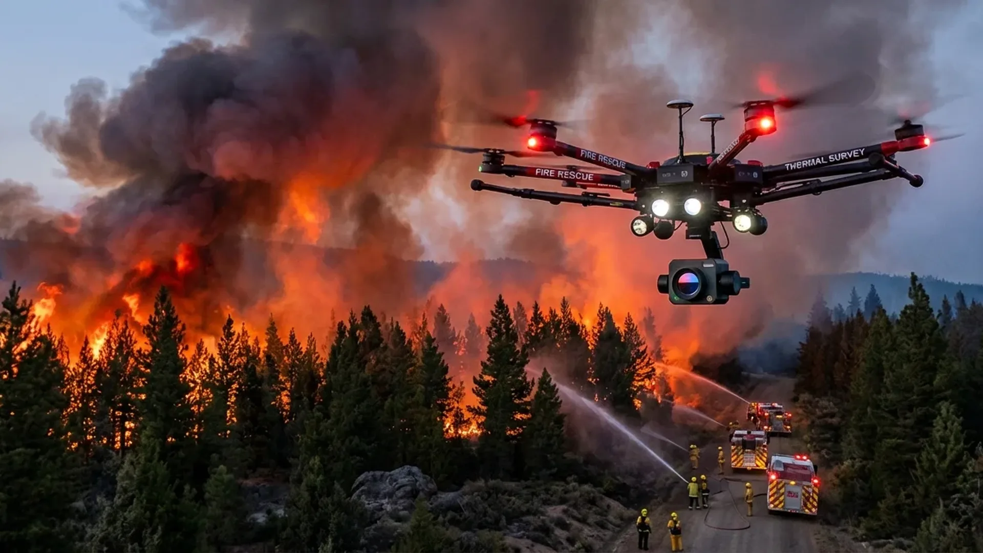
📡 How Firefighting Drones Work
Modern drones used in firefighting bear little resemblance to consumer models. These are specialized enterprise UAVs equipped with thermal imaging sensors, multispectral cameras, and gas detectors — technologies that Wikipedia identifies as key tools for environmental monitoring via UAVs.
Thermal Imaging
Detecting hotspots and thermal anomalies even through dense smoke at temperatures above 39°C (102°F) — something satellites like MODIS can do but with position errors of 2–3 km (Wikipedia). Drones offer centimeter-level precision.
Real-Time Streaming
Live video feed directly to the command center. According to DJI Enterprise, drones “improve response times, reduce operational costs and enhance decision-making.”
Gas Detection
Onboard gas sensors measure concentrations of CO, CO₂, and PM2.5 particulates — critical data since, according to the EPA, wildfire smoke emissions are 80–90% fine particles by mass.
Initiating Backfires
According to Wikipedia (UAV article), researchers are exploring “the use of UAVs to initiate backfires through pyrotechnic mechanisms” — a technique that can control fires without putting anyone in harm’s way.
🔬 Equipment: What Drones Do Firefighters Use
DJI, through its Enterprise Public Safety platform, offers specialized solutions for fire services. The most popular models for firefighting include:
| Model | Type | Thermal Camera | Approx. Price |
|---|---|---|---|
| DJI Mavic 3T | Compact thermal | FLIR 640×512 | ~€4,600 (~$5,000) |
| DJI Matrice 30T | Enterprise medium | Dual thermal + zoom | ~€9,200 (~$10,000) |
| DJI Matrice 350 RTK | Heavy-duty enterprise | H20T payload | €11,000–€18,400 (~$12K–$20K) |
| Autel EVO II Dual 640T | Thermal enterprise | 640×512, 30Hz | ~€7,500 (~$8,200) |
💡 Key Takeaway: DJI Enterprise states that drones in firefighting “offer thermal imaging for spotting hotspots in urban fires, wildfires, and more, ensuring effective, data-driven responses.” In practice, a single drone can replace hours of manual reconnaissance in just minutes.
🌲 Wildfires: Detection and Monitoring
Early Detection via UAV Swarms
One of the most promising technologies is UAV swarms — fleets of drones that monitor forested areas in real time. According to an IEEE publication (2018) cited in Wikipedia, mathematical models are being developed for “planning to monitor wildfires with a fleet of UAVs.” A later paper by Hu et al. (2022, Aerospace Science and Technology) describes “fault-tolerant cooperative navigation of networked UAV swarms for wildfire monitoring.”
The advantages over satellites are clear: while MODIS, AVHRR, and GOES satellite data provide useful coverage, they suffer from time delays and position errors of 2–12 km (Wikipedia, Wildfire). Drones fly at low altitude and deliver real-time data with accuracy measured in centimeters.
Satellite Detection
- Wide coverage spanning hundreds of km²
- Position error: 2–12 km
- Affected by cloud cover
- Limited time windows (polar orbits)
- Free data (NASA FIRMS)
Drone Detection
- Focused coverage on target area
- Centimeter-level accuracy (GPS/RTK)
- Operates even through thick smoke
- Real-time, on-demand data
- Equipment cost: €5,000–€20,000 (~$5.4K–$22K)
Post-Fire: Detecting Reignition Hotspots
Drone thermal cameras reveal “hidden” heat pockets beneath ash and soil — hotspots that could reignite days later. This is critical because, according to Wikipedia, “ground fires typically burn through slow combustion and may burn slowly for days to months.” Post-fire surveillance with drones saves hundreds of labor-hours.
🏘️ Urban Fires and Industrial Facilities
DJI Enterprise explicitly addresses the use of drones in “urban fires”: “Address urban fire incidents with drone thermal insights — improve response efforts by identifying hotspots and deploying teams more effectively.” In large industrial incidents or structural fires, drones:
- Assess the structural integrity of buildings before firefighters enter
- Detect trapped individuals through thermal signatures
- Map toxic gases at industrial sites (Hazmat response)
- Provide overhead views of tall buildings that ladders cannot reach
🔍 Search and Rescue (SAR)
DJI Enterprise dedicates an entire category to Search and Rescue: “First responders are turning to DJI’s aerial solutions for search and rescue missions. Drones can efficiently scan vast areas and locate individuals in distress using high-resolution sensors — both optical and thermal.” According to Wikipedia (UAV article), police drones are already used for “search and rescue and traffic monitoring” — applications that translate directly to fire services.
Locating Missing People
Thermal sensors detect human heat signatures across rough terrain, at night, or through smoke — impossible with the naked eye alone.
Communicating with Survivors
Drone-mounted speakers deliver evacuation instructions or help guide trapped individuals. Night-flight lights mark escape routes.
Delivering Supplies
According to Wikipedia, drones are used for “humanitarian aid — transporting food, medicine and essential goods to remote areas.”
🇬🇷 The Greek Reality
Greece is in a particularly vulnerable position. According to an academic study (Henderson et al., 2005 — Human Ecology Review) cited in Wikipedia, “wildfire activity is recognized as a significant factor in shaping ancient Greece. In modern Greece, it is the most common hazard-caused disaster and plays a significant role in the social and economic life of its people.”
Greece’s devastating wildfires
Record-breaking fires hit Evia, Attica, and the Peloponnese — thousands of hectares of forest were destroyed, forcing village evacuations. According to Wikipedia, they were linked to climate change.
CL-215GR crash near Karystos
In July 2023, a CL-215GR firefighting aircraft crashed near Karystos, Evia — two crew members lost their lives (Wikipedia, Aerial firefighting). A tragic reminder of the dangers crews face in the field.
Drones can handle the most dangerous reconnaissance missions — flying over active fire fronts, scanning nighttime hotspots, and mapping mountainous terrain — without any risk to human life. The Greek Fire Service has already begun using drones in pilot programs, while the EU funds related research through Horizon Europe.
⚠️ Challenges and Risks
Drones Interfering with Firefighting Operations
A serious challenge comes from unauthorized drones flying near active fires. According to Wikipedia (UAV article), in California in 2014–2015, hobbyist drones interfered with firefighting operations. Specifically, during the Lake Fire and North Fire, drone sightings forced the temporary suspension of aerial firefighting efforts. The US fine reaches up to $25,000. Similarly, in Greece fines for unauthorized flights range from €1,000 to €50,000 (~$1,100–$54,500), with potential imprisonment.
Technical Limitations
- Flight time: Most enterprise drones fly 30–45 minutes — insufficient for multi-hour operations
- Extreme temperatures: Near fire fronts (800°C / 1,472°F air, Wikipedia), electronics are at risk
- Strong winds: Fire whirls (>80 km/h / 50 mph) make flight impossible
- Regulations: Special permits are required for flights in emergency zones
🚨 Safety Rule: NEVER fly a recreational drone near an active fire. You will obstruct firefighting aircraft and drones, endanger lives, and face fines of €1,000–€50,000 (~$1,100–$54,500) in Greece or up to $25,000 in the US.
🚀 The Future: AI, Swarms, and Autonomous Missions
Technology is evolving rapidly. According to Wikipedia (Wildfire article), “the increasing frequency of wildfires has led to proposals for the development of artificial intelligence (AI)-based technologies for early detection, prevention, and prediction of wildfires.” Meanwhile, a Special Flight Operations Certificate (SFOC) was granted in Canada in August 2023 for drones supporting wildfire suppression.
AI-Powered Detection
Machine learning algorithms analyze thermal data in real time and predict fire spread direction based on terrain, weather, and vegetation patterns.
Autonomous Swarms
Fleets of 10–50 drones with fault-tolerant navigation (Hu et al., 2022) autonomously scan thousands of hectares while sharing data in real time.
Water/Retardant Drops
Heavy-lift drones (payload 30–50 kg / 66–110 lbs) are being tested for dropping small quantities of fire retardant at early stages — before a fire can spread.
💰 Cost and Return on Investment
A basic thermal drone for firefighting (e.g., DJI Mavic 3T) costs approximately €4,600 (~$5,000), while a full enterprise system (DJI Matrice 350 RTK + payloads + training) ranges from €15,000–€25,000 (~$16,300–$27,200). For comparison:
Helicopter Cost
- €3,000–€10,000 (~$3,300–$10,900)/hour
- Crew of 2–4 people
- Requires fuel refueling
- Cannot safely fly at night over fires
Drone Cost
- Minimal cost/hour (electric)
- 1 operator, training ~€300–€800 (~$330–$870)
- Battery swap in minutes
- Thermal camera: 24/7 flights
Given that wildfire smoke contributes to roughly 16,000 deaths annually (NPR/Nature, 2024 — cited in Wikipedia) with an estimated cost of $240 billion per year by 2050, the investment in drone prevention technology seems remarkably small relative to the benefits.
“Drones elevate public safety services by enhancing response times, reducing operational costs, and improving decision-making, while ensuring the safety of personnel in critical operations.” — DJI Enterprise, Public Safety
📋 Conclusions
Drones don’t replace firefighting aircraft or brave firefighters — they complement them. From thermal hotspot detection to UAV swarms scanning thousands of hectares, from search & rescue of trapped individuals to autonomous backfire operations, drone technology is now an indispensable tool in every modern fire service’s arsenal. For Greece — a country that battles the flames every single summer — adopting this technology is not a luxury. It is a necessity.