The construction industry — worth $8 trillion globally — faces chronic problems: according to McKinsey, the typical commercial construction project runs 80% over budget and is delayed by an average of 20 months. Drones are fundamentally changing this picture, with the construction drone market expected to reach $19 billion by 2032 (UAVCoach, 2026).
What Drones Bring to Construction
Integrating drones into the construction industry is no longer experimental — it's standard practice. According to UAVCoach (2026), 23% of certified drone pilots work in the construction/mining sector, making it the largest commercial drone use sector. Drones transform job sites into smart, data-driven environments.
10 Key Drone Applications on Job Sites
1. Site Surveying
Drones cover 120 acres/hour versus just 5 acres with traditional methods — a 60x efficiency increase. A 12-acre survey that would take 100 hours is completed in just 2 hours (UAVCoach, 2026).
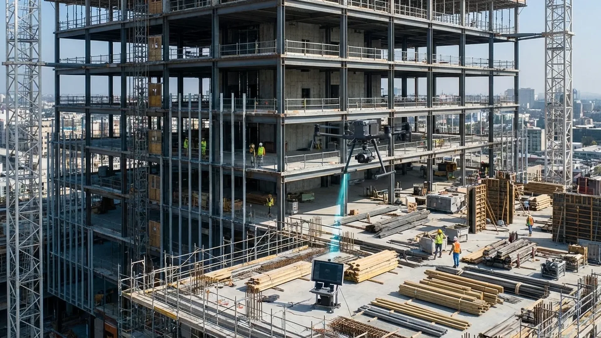
2. Progress Monitoring
Regular flights record construction progress with centimeter accuracy. Comparison with BIM (Building Information Models) identifies deviations in real time.
3. Safety Inspections
Drones inspect roofs, bridges, towers and hard-to-reach areas without risk to workers. Thermal cameras detect moisture, thermal bridges and structural defects.
4. Equipment Tracking
Real-time aerial photography locates machinery, materials and personnel on the job site, improving logistics management.
5. Stockpile Measurement
Volume calculation of aggregates, soil or concrete via 3D point clouds. Replaces time-consuming manual measurements with ±1-2% accuracy.
6. Quality Control
Equipped with high-resolution cameras, drones detect cracks, delamination, and severe deterioration at heights that are not easily accessible.
7. Environmental Monitoring
They record dust, emissions, water levels and vegetation around job sites. Essential for Environmental Impact Assessments (EIA).
8. Security & Surveillance
24/7 monitoring of job sites during non-working hours. Autonomous patrol flights with AI detect intruders, equipment or material theft.
9. Marketing & Communication
Impressive aerial progress videos. Ideal for presentations to investors, clients or media outlets.
10. Infrastructure Inspections
Bridges, highways, dams, tunnels — drones inspect critical infrastructure without requiring road closures or climbing.
ROI: Why the Investment Pays Off
According to McKinsey, approximately $3 trillion of the $8 trillion in annual construction industry revenue is lost to change orders, rework and delays. Drones dramatically reduce these losses (UAVCoach, 2026).
Survey Time Reduction
From 100 hours (traditional survey of 12 acres) to just 2 hours with a drone — a 98% time savings.
98% Time SavingsDrone Advantages
- ✅ 60x faster surveying
- ✅ Prevention of height-related accidents
- ✅ cm-level accuracy data
- ✅ 30-50% cost reduction
- ✅ Automated progress tracking
- ✅ Better stakeholder communication
- ✅ Eco-friendly monitoring
Challenges
- ⚠️ Initial equipment cost
- ⚠️ Pilot training & certification
- ⚠️ Licensing restrictions in urban job sites
- ⚠️ Weather conditions (wind, rain)
- ⚠️ Data security & GDPR
- ⚠️ Limited flight autonomy
Best Construction Drones 2026
Construction drones must combine durability in harsh conditions (dust, wind, moisture), high-resolution cameras, long flight time and RTK/PPK capability. According to UAVCoach (2026), these drones dominate job sites:
| Drone | Flight Time | Key Features | Price |
|---|---|---|---|
| DJI Matrice 350 RTK | 55 min | IP55, Zenmuse H20 series, O3 Enterprise, 2.7kg payload | €11,000 - €18,400 (~$12K - $20K) |
| DJI Mavic 3 Enterprise | 45 min | 20MP 4/3″ CMOS, 5.1K video, RTK module, 900g | ~€4,600 (~$5,000) |
| Skydio X10 | 40 min | AI obstacle avoidance, 50MP wide, NightSense, thermal | Enterprise pricing |
| Freefly Astro Max | 39 min | 3kg payload, Sony 61MP, IP43, open platform | €16,500 - €23,000 (~$18K - $25K) |
| Parrot ANAFI USA | 32 min | 32x zoom, FLIR thermal, 500g, secure by design | Enterprise pricing |
Tip: For small job sites (<5 acres), the DJI Mavic 3 Enterprise (~€4,600 / ~$5,000) covers most needs. For large projects, the Matrice 350 RTK with interchangeable payloads (LiDAR, thermal, zoom) is the industrial solution.
Construction Drone Workflow
Flight Planning
Define the area of interest, flight altitude (typically 50-120m), photo overlap (70-80% frontal, 60-70% lateral) and GCPs (Ground Control Points) for cm-level accuracy.
Autonomous Flight & Data Capture
Automated grid pattern flights using DroneDeploy, Pix4Dcapture or DJI Pilot 2. Capture hundreds of geotagged photos per flight.
Upload & Processing
Upload to cloud (DroneDeploy, Pix4Dcloud) or desktop (Agisoft Metashape, Pix4Dmapper). Photogrammetric processing produces orthomosaics, DSM/DTM and 3D models.
Analysis & Measurements
Volume calculations, distances, slopes. Comparison with BIM models for progress tracking. Identification of deviations from plans.
Reports & Sharing
Automatic report generation with orthophotos, 3D views, measurements. Share with stakeholders via web links without specialized software.
Repeat & Temporal Comparison
Regular flights (weekly/monthly) create a time series of data. Time-lapse analysis shows progress and identifies delays.
Construction Drone Service Costs
| Service | Cost | Notes |
|---|---|---|
| Job site survey | €300 - €1,500 (~$325 - $1,630) /flight | Depends on area & accuracy (RTK/PPK) |
| Monthly progress monitoring | €500 - €2,000 (~$545 - $2,175) /month | 4 flights/month, reports & BIM overlay |
| Building inspection | €200 - €800 (~$220 - $870) | Photo + thermal inspection |
| 3D modeling | €500 - €3,000 (~$545 - $3,260) | Point cloud + textured mesh |
| Stockpile measurement | €200 - €600 (~$220 - $650) | ±1-2% volume calculation accuracy |
| Freelance drone pilot | €45 - €120 (~$50 - $132) /hour | Depends on certifications & equipment |
Drones in Greek Construction
Greece is undergoing major construction projects — highways (E-65, Crete), Thessaloniki Metro, port reconstructions, tourism resorts, renewable energy (wind farms, solar parks). Drones are already being utilized in:
Road Works & Infrastructure
Route surveying for national highways, monitoring bridge, tunnel and interchange construction. Real-time excavation volume measurement.
Building Construction
Progress monitoring for apartment buildings and commercial properties. Thermal inspection of insulation. Comparing actual construction with BIM architectural models.
Monument Restoration
Greece, with thousands of archaeological sites, uses drones for documentation, 3D scanning of monuments and monitoring restoration work — without scaffolding that could endanger monuments.
Renewable Energy
Site surveying for solar parks, wind turbine inspection at heights >100m, thermal analysis of panels to identify defective cells.
Regulations & Licensing
Commercial drone use is regulated by EASA (EU) 2019/947 in Europe (FAA Part 107 in the US):
- Operator registration: Mandatory with the national aviation authority — free in most EU countries
- A2 or Specific Category: Most job sites require A2 certification (~€50-€100 / ~$55-$110) or STS scenario (~€300-€800 / ~$325-$870) due to proximity to people
- Insurance: Mandatory liability — minimum €1M (~$1.1M) for commercial use (~€150-€500 / ~$165-$545 per year)
- Flight zones: Check via national NOTAM systems or DJI FlySafe — many urban job sites are near airports or restricted zones
- Remote ID: Mandatory from 2026 for drones >250g — equipment ~€90-€275 (~$100-$300)
- Penalties: €1,000-€50,000 (~$1,100-$54,350) for violations, up to 3 years imprisonment in serious cases
"The construction drone market is expected to reach $11.96 billion by 2027 and $19 billion by 2032. Drones don't replace engineers — they give them superpowers."
— UAVCoach, Construction Drone Market Analysis, 2026AI & Automation: The Future
The new generation of construction drones integrates artificial intelligence:
- Autonomous flights: Drones like the Skydio X10 use AI obstacle avoidance for flights in complex job sites without human intervention
- Computer Vision: Automatic detection of cracks, rust, delamination in real-time during flight
- Digital Twins: Automatic updating of building digital twins after each flight — complete mapping between physical and digital worlds
- Predictive Analytics: AI algorithms predict delays, safety risks and maintenance needs
- Swarm Technology: Multiple coordinated drones cover large job sites simultaneously
Frequently Asked Questions (FAQ)
Do I need a special license for a drone on a job site?
Yes. In the EU, at least an A2 or Specific Category (STS) certification is required due to proximity to people. In the US, FAA Part 107 is mandatory. Liability insurance and operator registration are also required.
What's the best drone for small job sites?
The DJI Mavic 3 Enterprise (~€4,600 / ~$5,000) offers excellent value: 45-minute flight time, RTK, 20MP 4/3″ camera and compact size for easy transport between sites.
How much does drone surveying cost?
A job site survey costs €300-€1,500 (~$325-$1,630) per flight, while monthly progress monitoring ranges from €500-€2,000 (~$545-$2,175)/month. Freelance pilots charge €45-€120 (~$50-$132)/hour.
Can drones fly in bad weather?
Enterprise drones (e.g., Matrice 350 RTK with IP55) withstand light rain and winds up to 12 m/s. In storms or heavy rainfall, flight is not recommended for safety and data quality reasons.