What Is Drone Photogrammetry
Photogrammetry is the science of extracting reliable information — geometric, topographic, thematic — from photographic images. It relies on the principle of stereophotogrammetry: by combining multiple overlapping captures (overlap 70-80%, sidelap 60-70%), Structure from Motion (SfM) algorithms reconstruct three-dimensional coordinates of every point through triangulation.
- Point Cloud: Millions of 3D points with color information (RGB)
- Orthomosaic: High-resolution georeferenced image, geometrically corrected
- DSM (Digital Surface Model): Digital surface model — includes buildings, vegetation
- DTM/DEM (Digital Terrain Model): Digital terrain model — bare earth surface only
- 3D Textured Mesh: Three-dimensional model with texture, ideal for visualization
- Contour Lines: Contour lines for topographic diagrams
Photogrammetry vs LiDAR
While photogrammetry relies on RGB images, LiDAR (Light Detection and Ranging) emits laser beams and measures return time. DJI’s Zenmuse L2 supports 5 returns, meaning that in dense vegetation it can “penetrate” through foliage and record points on the actual ground — something impossible with photogrammetry alone.
| Feature | Photogrammetry | LiDAR |
|---|---|---|
| Accuracy (RTK) | 1-3 cm (horizontal), 2-5 cm (vertical) | 4 cm vertical, 5 cm horizontal |
| Vegetation performance | Limited (requires visible ground) | Excellent (5 returns, canopy penetration) |
| GSD (Ground Sampling Distance) | 1-3 cm/pixel depending on altitude | Spot 4×12 cm @100m |
| Coverage per flight | 0.5-2 km² | 2.5 km² (Zenmuse L2) |
| Payload cost | Lower (camera) | Higher (LiDAR module) |
| Ideal for | Open areas, construction, mines | Forests, power lines, archaeology |
Advantages vs Traditional Methods
Aerial topographic surveys with drones have fundamentally changed the way engineers and surveyors work. Compared to traditional methods — total station, handheld GPS RTK, or even manned aerial photography — drones offer tremendous advantages:
10× Faster Surveying
An area of 5 hectares that takes 2-3 days with a total station can be surveyed in <1 hour of flight time + processing.
40-60% Cost Reduction
Fewer personnel in the field, lower equipment transport costs, faster project completion times.
Personnel Safety
Map dangerous areas (rocky terrain, quarries, landslides) without risk to surveyors on the ground.
Complete Ground Coverage
Unlike individual total station points, drones capture millions of data points per km².
Aerial photogrammetry with drones doesn’t replace the surveyor — it equips them with data of unprecedented density and accuracy, turning days of fieldwork into hours.
Top Drones for Topographic Surveys
Survey drones fall into two categories: multirotor (vertical takeoff/landing, ideal for small to medium areas) and fixed-wing (for large areas). The top models of 2026:
| Model | Type | Flight Time | Payload | Price |
|---|---|---|---|---|
| DJI Matrice 350 RTK | Multirotor | 55 minutes | 2.7 kg (Zenmuse L2/P1) | €11,000-18,400 (~$12K-20K) |
| DJI Mavic 3 Enterprise RTK | Multirotor | 43 minutes | Built-in 4/3 CMOS | ~€4,600 (~$5,000) |
| senseFly eBee X | Fixed-wing | 90 minutes | S.O.D.A. 3D / senseFly Aeria X | €13,800-23,000 (~$15K-25K) |
| WingtraOne Gen II | VTOL Fixed-wing | 59 minutes | Sony RX1R II (42MP FF) | €18,400-27,600 (~$20K-30K) |
DJI Matrice 350 RTK — The Survey King
The Matrice 350 RTK is DJI Enterprise’s flagship. With IP55 certification, operating temperatures from -20°C to +50°C, 20 km transmission range (O3 Enterprise), 6-directional obstacle avoidance, and dual-battery hot-swap (TB65 — 400 cycles), it’s built for the most demanding survey missions.
Payloads: Zenmuse L2 & Zenmuse P1
The heart of every survey drone is the payload — the sensor that captures the data. DJI offers two top-tier solutions:
Zenmuse L2 (LiDAR)
- Frame LiDAR + 4/3 CMOS 20MP RGB
- Vertical accuracy: 4 cm
- Horizontal accuracy: 5 cm
- 240,000 pts/s effective rate
- Range: 250m @10% · 450m @50%
- 5 Returns — vegetation penetration
- 2.5 km² coverage per flight
- No IMU warm-up required
Zenmuse P1 (Photogrammetry)
- Full-frame sensor 45MP
- Interchangeable lenses (24/35/50mm)
- Mechanical shutter (no rolling shutter)
- GSD: 1.2 cm/pixel @100m (35mm)
- TimeSync 2.0 μs-level sync
- Smart Oblique capture
- Ideal for open areas
- RTK/PPK support
Data Processing Software
After capture, data must be processed in specialized software. The top programs:
| Software | Type | Key Features | Price |
|---|---|---|---|
| DJI Terra | Desktop | One-click processing, PPK, DEM, L2 integration | ~€2,700-5,500/yr (~$2,900-6,000) |
| Pix4Dmapper | Desktop/Cloud | 1-2 pixel GSD, GCPs, classification, rayCloud | ~€260/mo (~$280) or €3,500 (~$3,800) perpetual |
| Agisoft Metashape Pro | Desktop | SfM, dense cloud, DEM, ortho, mesh export | ~€3,300 (~$3,600) perpetual |
| OpenDroneMap | Open Source | Free, community-driven, WebODM GUI | Free |
After image capture, Pix4Dmapper processes them automatically: initial alignment → bundle adjustment → dense point cloud → DSM → orthomosaic. For accuracy <3 cm, at least 5-10 GCPs (Ground Control Points) measured with GNSS RTK are required. Deliverables are exported in standard formats: .las/.laz (point cloud), GeoTIFF (orthomosaic, DSM), .obj/.ply (3D mesh).
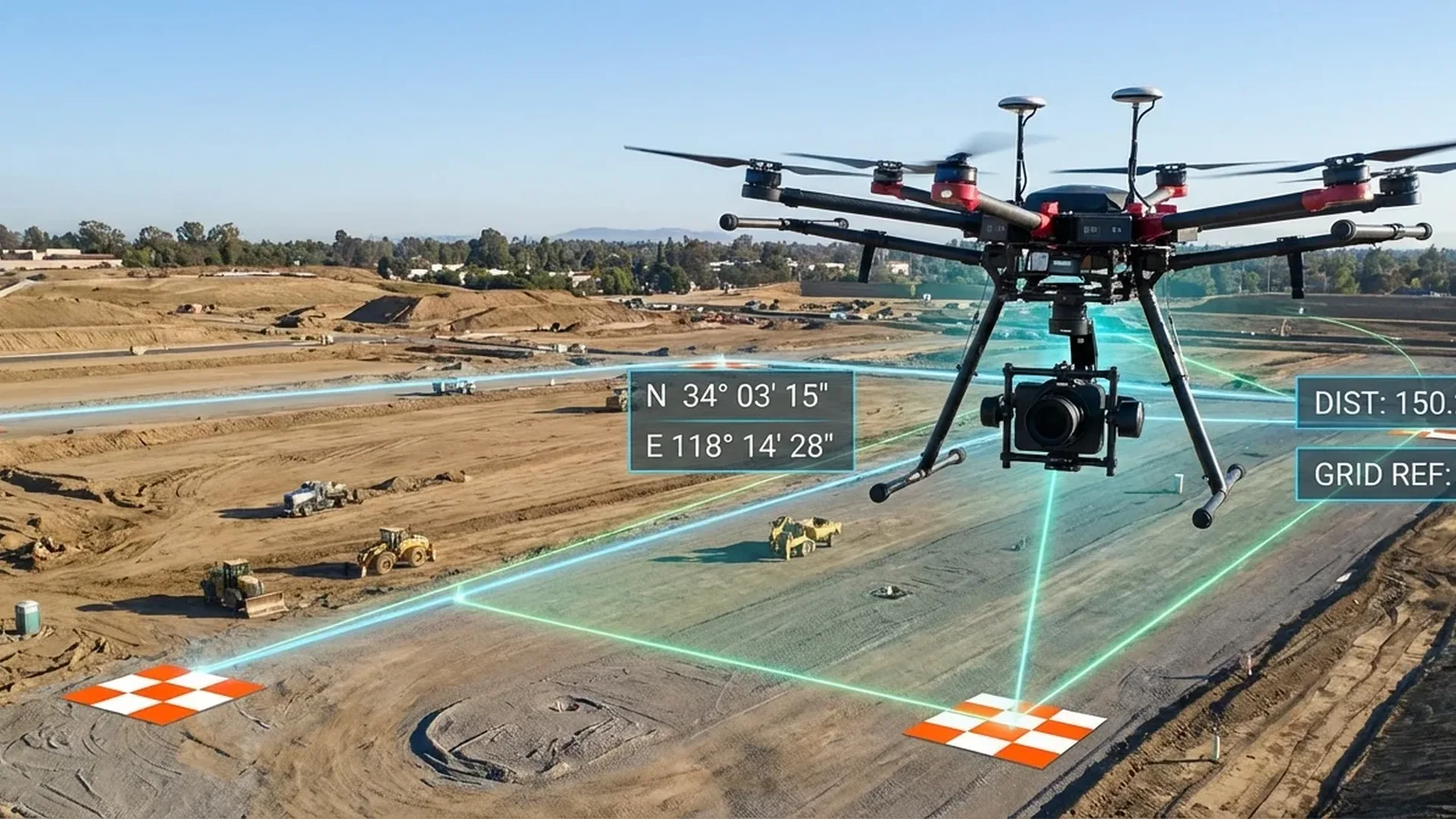
Topographic Survey Workflow
Flight Planning
Define area, flight altitude (80-150m), overlap (70-80%), sidelap (60-70%). Use DJI Pilot 2 or Pix4Dcapture. On uneven terrain, enable Terrain Follow.
GCP Placement
5-10 ground control points measured with GNSS RTK, evenly distributed across the survey area for accuracy optimization.
Flight & Data Acquisition
Automated flight (waypoint/area route). With Matrice 350 RTK, 2.5 km² coverage per flight. Real-time point cloud preview in DJI Pilot 2.
Data Processing
Import into DJI Terra or Pix4Dmapper. PPK post-processing if needed. Generate point cloud, DSM/DTM, orthomosaic, contour lines.
Quality Control & Delivery
Compare with GCPs/checkpoints, accuracy report. Export in GIS-compatible formats (.shp, GeoTIFF, .dxf) for client delivery.
Real-World Applications
Construction
Progress monitoring, earthwork calculations, as-built models, BIM integration
Mines & Quarries
Stockpile volume calculations, extraction planning, slope safety monitoring
Agriculture
Field mapping, DTM for drainage, precision irrigation design
Archaeology
3D documentation of excavations, monument recording, digital preservation
Roads & Infrastructure
Road design, bridge studies, longitudinal/cross sections
Energy & Utilities
Power line inspection, pylon mapping, vegetation management
Accuracy: RTK, PPK & GCPs
RTK (Real-Time Kinematic)
The drone receives GNSS corrections in real time from a base station or CORS network (e.g., HxGN SmartNet). Positioning accuracy: 1-2 cm. Requires continuous radio link with the base station.
PPK (Post-Processing Kinematic)
Raw GNSS data is stored during flight and corrected afterward in the office. Ideal for areas without RTK coverage or in case of signal loss. DJI Terra fully supports PPK workflow for the Zenmuse L2.
GCPs (Ground Control Points)
Physical reference points on the ground, measured with millimeter accuracy. Place 5-10 per survey, evenly distributed. Combining RTK + GCPs yields optimal accuracy (<2 cm horizontal, <3 cm vertical).
GSD determines the resolution: how many centimeters each pixel represents in the orthomosaic. Typical values: 1-3 cm/pixel at 80-150m altitude. Pix4Dmapper achieves accuracy of 1-2 pixel GSD horizontally and 1-3 pixel GSD vertically — meaning at 2 cm GSD, accuracy is 2-4 cm horizontal and 2-6 cm vertical.
Equipment & Service Costs
Equipment Costs
Entry-Level
- Built-in 4/3 CMOS camera
- 43 minutes flight time
- GSD ~1.2 cm/pixel @100m
- Ideal for small areas
Professional
- LiDAR 4cm accuracy or 45MP FF
- 55 minutes flight, IP55
- 2.5 km² per flight (L2)
- The top enterprise solution
Fixed-Wing
- 59-90 minutes flight time
- Coverage >10 km² per flight
- Ideal for massive areas
- VTOL (WingtraOne) or hand-launch
Service Costs
| Service | Price | Notes |
|---|---|---|
| Basic survey (<1 hectare) | €500-1,500 (~$540-1,630) | Orthomosaic, DSM, 2D |
| Survey 1-5 hectares | €1,500-3,500 (~$1,630-3,800) | Full package with GCPs |
| Large survey (>5 hectares) | €3,500-8,000+ (~$3,800-8,700+) | LiDAR, point cloud, DTM/DSM |
| Stockpile volume calculation | €300-800 (~$325-870) | Per survey session |
| 3D model building/monument | €1,000-5,000 (~$1,090-5,440) | Varies by complexity |
Regulatory Framework
Commercial drone flights for surveying fall under the Specific Category of EASA regulations, especially when using enterprise drones (>4 kg or flying in special zones). The operator needs:
- A1/A3 certificate (free, online — baseline) + A2 (~€50-100 / ~$55-110)
- STS (Standard Scenario) training — ~€300-800 (~$325-870) per scenario
- Operator & drone registration with the national aviation authority (free)
- Remote ID on enterprise drones (~€90-275 / ~$100-300)
- Liability insurance €1,000,000 minimum (~€150-500/year / ~$165-545)
- Operational Authorization for Specific Category
Conclusions
Topographic surveys with drones have become the norm — not the exception — in construction projects, mines, farms, and archaeological sites. With accuracy <5 cm, 2.5 km² coverage per flight, and 40-60% lower costs than traditional methods, investing in drone survey equipment or services pays off quickly. LiDAR technology (Zenmuse L2) opens new possibilities in forested and densely vegetated areas, while photogrammetry (Zenmuse P1) remains the optimal solution for open fields. Whatever your requirements, drones are transforming the way we see — and measure — the earth.